sagrado
Sagrado Railway Bridge
Roberto OCERA
Alessandro OCERA
Alessandro OCERA
HISTORY
In 1949, planners conceived an upgrade project for the Pontebbana railway line that would connect the stations of Redipuglia and San Giovanni al Natisone. The project had three main objectives during a period of particular political instability: shortening the route by approximately 14 km, doubling the Sagrado-Cormons section, and widening the bridge over the Isonzo River. The project was periodically included in the ten-year railway development plans, with oversight alternating between Ente Ferrovie dello Stato (the State Railways Authority) and Nuove Costruzioni Ferroviarie (more specifically the General Directorate of Ordinary Roads and New Railway Constructions of the Ministry of Public Works).Finally, the project proceeded in phases from the early 1960s through 1988, culminating with the completion of the Gorizia-Villesse motorway link overpass. Earlier works had included building the bridges over the Isonzo and Versa rivers, the overpasses in Fogliano and Cormons, and service facilities—one in Mariano del Friuli (since then demolished) and another left incomplete in Borgo Trevisan in Gradisca d’Isonzo. The project was eventually abandoned in 1989 before rail tracks could be laid, though, during this same period, the second track was laid on the Sagrado-Gorizia-Cormons section.
The Redipuglia-Cormons bypass was designed to significantly enhance rail freight efficiency in Friuli Venezia Giulia through strategic infrastructure development. By establishing a direct connection between the railway junctions of Redipuglia and Cormons, this route would eliminate the historical requirement to pass through Gorizia—a route established by the original Habsburg railway system of 1860. The modification would optimise the Trieste-Tarvisio corridor by reducing the distance by 15 kilometres, representing a 10 per cent improvement in efficiency. This project, developed under law 298/58, was led by engineer Paolo Pellis, whose expertise was internationally recognised. Construction began in 1963 and stretched into the early 1990s. Major works included a substantial viaduct in the centre of Fogliano-Redipuglia (requiring the demolition of seven houses), a steel bridge crossing the Isonzo River in Sagrado, and an additional viaduct through Cormons. The year 1969 marked the inauguration of Cormons’s modernised station, which was outfitted with comprehensive signalling and electrical infrastructure in preparation for the line’s commencement. in anticipation of the line’s operation. However, the project’s trajectory changed when the President of the Railways Authority redirected priorities toward completing the Monfalcone-Cervignano-Udine corridor despite the ministry’s imminent timeline authorisation. This strategic shift aimed to reinforce the Cervignano logistics hub. Consequently, the Redipuglia-Cormons line remained unfinished—a decision partly shaped by Gorizia’s political leadership, who feared the bypass would isolate their city.
In 1989, a significant development occurred when Gorizia’s mayor endorsed the project’s completion, leading to substantial investment in a new iron flyover above the Gorizia-Villesse motorway link. Yet once completed, work stalled again. Upon ministerial inquiry in 1992, the Railways Authority responded that while the line remained technically viable, they would not proceed with completion—despite the fact that finishing would have required only a modest investment compared to the infrastructure costs already incurred. Following the decision to abandon the project, some structures—like the Fogliano and Cormons viaducts—have since been demolished, while others have been repurposed. The A34 Gorizia Villesse motorway, now modernised to current traffic standards, was connected to the state road via a bypass through Mariano del Friuli. This bypass avoids the urban centre by efficiently utilising portions of the former Redipuglia-Cormons railway corridor. Furthermore, the iron flyover underwent strategic repositioning to accommodate both agricultural vehicle access and pedestrian-cyclist infrastructure.
BRIDGE CONSTRUCTION AND STRUCTURAL ENGINEERING
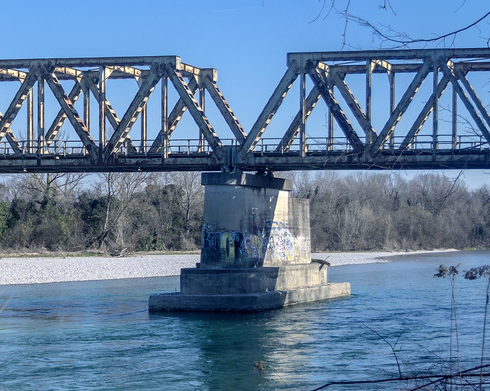
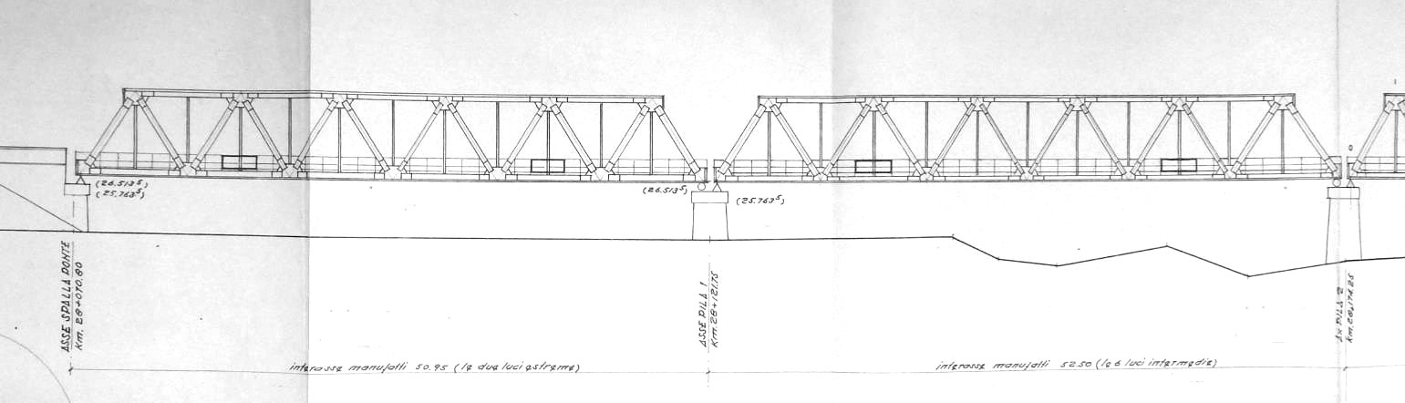
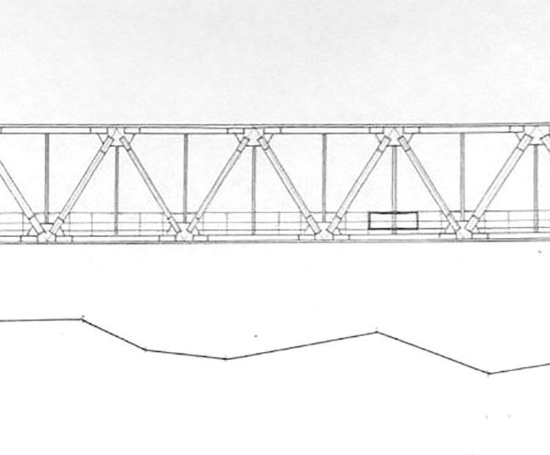
The metal bridge features eight spans of varying lengths. The outer spans measure 50.95 metres from the abutment axis to the pier axis, while the central spans measure 52.50 metres between pier axes, as verified by comprehensive surveys. The bridge’s overall cross-section measures approximately 5.90 × 7.20 metres in height.Structurally, the bridge consists of eight separate spans, each supported independently through a system of hinges and rollers, as illustrated below. The roller mechanism features lateral blocks that serve two purposes: absorbing lateral wind pressure (a key consideration in the building standards regulations of the time) and controlling irregular train axle movements along the track. These forces are then efficiently transferred to the main structure via longitudinal support beams (stringers).
The bridge, which spans the Isonzo River, was constructed by Giacomo Galtarossa—Metal and Mechanical Constructions—of Padua as part of the project’s fourth executive lot. All contract documentation was retrieved from the Public Works Ministry Library at Via Nomentana 2 in Rome.
Although the bridge’s testing certificate and financial records could not be located following changes in ownership, documentation from the State Railways confirms the structure meets the required load-bearing specifications. A waterway crossing permit—which fell under Civil Engineering Corps jurisdiction until 2004 before transferring to the Autonomous Region of Friuli Venezia Giulia—was not secured, as the State Railways had not received complete hydraulic data from the Gorizia Civil Engineering Corps. The bridge, documented in official records, remained under Rete Ferroviaria Italiana (Italian Railway Network) ownership until its interim transfer to the Province of Gorizia in 2010, pending permanent reassignment.
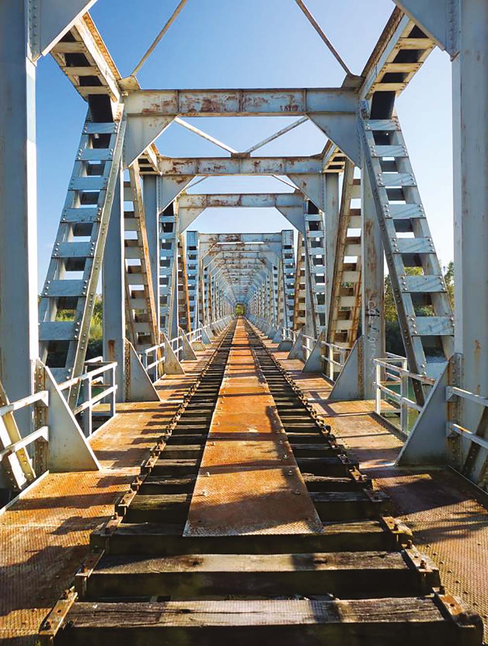
The infrastructure, built over four decades ago, has experienced a period of deferred maintenance. Upon inspection, while the steel components have maintained structural integrity with consistent thickness measurements, deterioration is primarily evident in the pedestrian walkway components—specifically the wooden railway ties and their associated non-slip metal plating. The assessment confirms the structural integrity remains intact, with specialised contractors verifying the soundness of all riveted connections through systematic evaluation.
BRIDGE CONSTRUCTION AND STRUCTURAL ENGINEERING
The metal bridge features eight spans of varying lengths. The outer spans measure 50.95 metres from the abutment axis to the pier axis, while the central spans measure 52.50 metres between pier axes, as verified by comprehensive surveys. The bridge’s overall cross-section measures approximately 5.90 × 7.20 metres in height.Structurally, the bridge consists of eight separate spans, each supported independently through a system of hinges and rollers, as illustrated below. The roller mechanism features lateral blocks that serve two purposes: absorbing lateral wind pressure (a key consideration in the building standards regulations of the time) and controlling irregular train axle movements along the track. These forces are then efficiently transferred to the main structure via longitudinal support beams (stringers).
The bridge, which spans the Isonzo River, was constructed by Giacomo Galtarossa—Metal and Mechanical Constructions—of Padua as part of the project’s fourth executive lot. All contract documentation was retrieved from the Public Works Ministry Library at Via Nomentana 2 in Rome.
Although the bridge’s testing certificate and financial records could not be located following changes in ownership, documentation from the State Railways confirms the structure meets the required load-bearing specifications. A waterway crossing permit—which fell under Civil Engineering Corps jurisdiction until 2004 before transferring to the Autonomous Region of Friuli Venezia Giulia—was not secured, as the State Railways had not received complete hydraulic data from the Gorizia Civil Engineering Corps. The bridge, documented in official records, remained under Rete Ferroviaria Italiana (Italian Railway Network) ownership until its interim transfer to the Province of Gorizia in 2010, pending permanent reassignment.
The infrastructure, built over four decades ago, has experienced a period of deferred maintenance. Upon inspection, while the steel components have maintained structural integrity with consistent thickness measurements, deterioration is primarily evident in the pedestrian walkway components—specifically the wooden railway ties and their associated non-slip metal plating. The assessment confirms the structural integrity remains intact, with specialised contractors verifying the soundness of all riveted connections through systematic evaluation.
CURRENT STATE AND FUTURE DEVELOPMENTS
What should be done with the Isonzo bridge? The former Province administration has proposed transforming it into a dedicated pedestrian and cycling connection between two regions: the Carso (in the south, where Mount San Michele—site of bloody World War I battles—is accessible within a few kilometres from nearby Sagrado) and the Collio hills to the north, where Cormons, the jewel of Friulian winemaking, lies about ten kilometres away. This initiative has been formally integrated into the 2015-2017 three-year development program of the project “Gorizia-Grado bicycle path (international route) on the bed of the unfinished railway line.”Before proceeding with the bicycle path development across the Isonzo River along the existing railway corridor, engineers needed to verify the structural integrity of the existing bridge. Following a thorough evaluation of the static integrity certification, which validated the structure’s capacity to accommodate both pedestrian-cycling traffic and support a metal water pipeline infrastructure, the provincial council formally authorised this dual-purpose utilisation.