grado

Monfalcone-Grado Regional Road Bridge
HISTORY
The bridge on the Monfalcone-Grado suburban road lies in the southern part of the Agro Monfalconese, an area between the great bend of the lower Isonzo River and the Carso foothills. This area, which borders the Grado Lagoon, has been shaped through centuries by the shifting Isonzo delta—a complex river mouth system formed by the Natisone (known to Romans as Natiso) and Isonzo Rivers (recorded in Roman times as Sontius or Suntius). From the beginning of the Common Era, the main mouth of this delta system—which flowed from the town of Pieris to the sea through the great basin of Fossalon via the mouths of Mondina, Primero (Portus Primarius), and Averto—gradually shifted eastward. The Isonzo’s main branch slowly moved toward today’s Isonzato, finally reaching the current Sdobba branch in 1936. This hydrographic transformation, accelerated by severe weather events, floods (mid-6th century), and ground subsidence, dramatically altered the environment and landscape. As the Isonzo deposited sediment along the coastal strip, expanding swamps and malarial marshlands, people gradually abandoned the countryside for safer areas to the north—an exodus that continued until the 17th century. The early 19th century saw the beginning of various hydraulic and agricultural improvements, though these lacked coordinated planning until the second half of the century. In 1866, engineer R. Angelo Vicentini proposed a comprehensive project backed by forward-thinking agricultural entrepreneurs, including Antonio de’ Dottori.For centuries after its patriarchal golden age, Grado remained largely undeveloped. Following the collapse of the thousand-year-old Venetian Republic, the island came under Habsburg rule, which laid the groundwork for its tourism industry. A pivotal moment came on 25 June 1892, when Emperor Franz Joseph’s law officially designated Grado and its surrounding area as a “health and holiday resort.”
By the early 1900s, Grado had established itself as a health and holiday destination. However, the island remained difficult to access despite the establishment of steamboat companies in 1896 that provided transportation for both passengers and goods.
Tourism ceased with the outbreak of World War I, and recovery proceeded slowly. The Curatorium oversaw the bathing establishment but wasn’t re-established until 1921.
In 1933, the Hotel Propaganda group submitted a report to the Provincial Tourism Committee of Gorizia highlighting Grado’s isolation from the mainland and advocating for a bridge to permanently connect Testata Mosconi (the end of the trans-lagoon road) with the island. As a result, a swing bridge was designed in 1934 and inaugurated in June 1936, linking Grado to the mainland near Aquileia.
During this period, extensive land reclamation works continued in the eastern area of the Grado lagoon toward the Agro Monfalconese, creating the agricultural territories of Boscat and Fossalon. These improvements made it possible to construct a road providing more direct access between Grado and the Julian territory, including the cities of Trieste, Gorizia, and Monfalcone.
In 1950, a bridge was constructed on Provincial Road No. 19 (now Regional Road GO 19), spanning the Isonzo River between Rondon and Terranova in the municipality of San Canzian d’Isonzo. The bridge served a dual purpose, also supporting an aqueduct pipeline that distributed drinking water to the reclaimed areas.
BRIDGE CONSTRUCTION AND STRUCTURAL ENGINEERING
Located on Regional Road GO 19 (formerly Provincial Road No. 19), the bridge connects the municipalities of Monfalcone and Grado between kilometre 6.368 and 6.782.The structure features a 6.5-metre-wide road carriageway with two lanes and sidewalks. Supporting significant daily traffic volumes of some 3,000 vehicles—including 2,000 heavy vehicles exceeding 3.5 tonnes —the structure extends 414 metres in length and 9.70 metres in width. Enhanced safety features include tubular steel parapets with handrails and two intermediate rails. Its design incorporates 15 spans of variable lengths—up to 27.65 metres—with integrated expansion joints ensuring structural integrity.
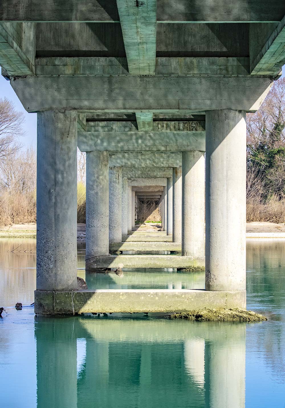
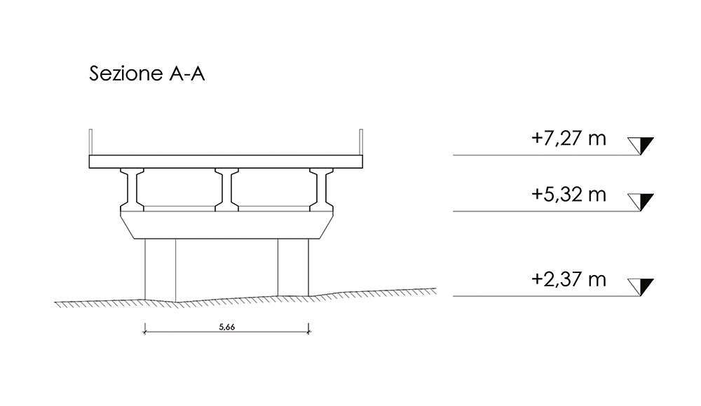
The bridge’s foundation system comprises non-inspectable piles supporting two abutments and thirteen strategically placed portal piers within the riverbed. Each pier element, extending to 6.3 metres in height, incorporates twin cylindrical shafts measuring 1.0 metre in diameter, topped with a pier cap—all engineered using reinforced concrete construction.
The deck employs a straight girder configuration with a uniform cross-section, incorporating prestressed reinforced concrete double T-beams. The deck structure features fifteen distinct spans, with an arrangement of forty-five beams (distributed as three per span) and thirty cross beams (positioned two per span) providing comprehensive support.
BRIDGE CONSTRUCTION AND STRUCTURAL ENGINEERING
Located on Regional Road GO 19 (formerly Provincial Road No. 19), the bridge connects the municipalities of Monfalcone and Grado between kilometre 6.368 and 6.782.The structure features a 6.5-metre-wide road carriageway with two lanes and sidewalks. Supporting significant daily traffic volumes of some 3,000 vehicles—including 2,000 heavy vehicles exceeding 3.5 tonnes —the structure extends 414 metres in length and 9.70 metres in width. Enhanced safety features include tubular steel parapets with handrails and two intermediate rails. Its design incorporates 15 spans of variable lengths—up to 27.65 metres—with integrated expansion joints ensuring structural integrity.
The bridge’s foundation system comprises non-inspectable piles supporting two abutments and thirteen strategically placed portal piers within the riverbed. Each pier element, extending to 6.3 metres in height, incorporates twin cylindrical shafts measuring 1.0 metre in diameter, topped with a pier cap—all engineered using reinforced concrete construction.
The deck employs a straight girder configuration with a uniform cross-section, incorporating prestressed reinforced concrete double T-beams. The deck structure features fifteen distinct spans, with an arrangement of forty-five beams (distributed as three per span) and thirty cross beams (positioned two per span) providing comprehensive support.
CURRENT STATE AND FUTURE DEVELOPMENTS
Between October 2018 and July 2023, comprehensive safety assessments were conducted on the bridge in accordance with the Ministry of Infrastructure and Transport’s updated safety protocols, implemented following the Morandi Bridge incident in Genoa. Current evaluations confirm the bridge’s structural integrity, though recommended improvements include supplementary assessments, remediation of specific structural elements, and implementation of enhanced safety barriers to replace the current guardrail system.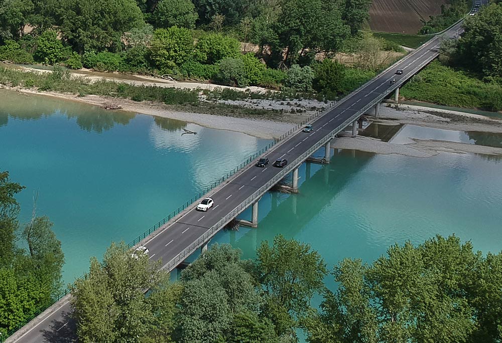
Drone photo by: F. Bergamasco
